By Zuzana Bednarik, Ph.D.
Researchers, federal agencies, and policymakers may employ different definitions of rural and urban. For example, some definitions use population density as a defining factor. In other cases, it is geographic isolation or commuting patterns. This section highlights definitions of rural and urban used by the North Central Regional Center for Rural Development (NCRCRD) and emphasizes differences that exist between their defining criteria.
NCRCRD uses the U.S. Census Bureau’s and OMB’s delineations of rural and urban areas for research and statistical purposes. The definitions provided below are a short primer to the rural and urban distinctions between federal agencies.
1. U.S. Census Bureau’s urban and rural areas
The U.S. Census Bureau defines rural and urban areas on the basis of population size and density.[1],[2],[3]
Metro (urban) areas consist of two types and are delineated primarily based on population density or the extent to which areas are built-up and densely settled.
- Urbanized areas contain a population of 50,000 or more. They may or may not contain any individual cities of 50,000 or more. In general, they must have a core with a population density of 1,000 persons per square mile and may contain adjoining territory with at least 500 persons per square mile.
- Urban clusters have at least 2,500 people but fewer than 50,000 residents. In general, they must also have a core with a population density of 1,000 persons per square mile and may contain adjoining territory with at least 500 persons per square mile.
Nonmetro (rural) areas consist of
- open countryside with population densities less than 500 people per square mile, and
- places with fewer than 2,500 people
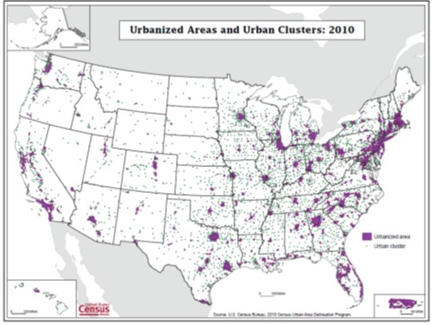
The Census Bureau defines urban areas after each decennial census. Based on this definition, in 2010, urbanized areas contained 71.2% of the population, while 9.5% were within urban clusters. The rural areas of the United States contained 19.3% of the population (Figure 1).[4]
Figure 1. U.S. Census Bureau’s urban and rural areas, 2010

Source: U.S. Census Bureau: Defining Rural at the U.S. Census Bureau. 2016
2. Metropolitan and Micropolitan statistical areas
The Census Bureau’s delineation of urban areas and urban clusters provides the basis for the Office of Management and Budget’s (OMB) delineation of Core Based Statistical Areas or Metropolitan (metro) and Micropolitan (micro) statistical areas. Metro and micro areas are nationally delineated for statistical purposes. “Nonmetropolitan is often used synonymously with rural, and while there is overlap, these geographic entities are not identical and should not be used interchangeably”. [5]
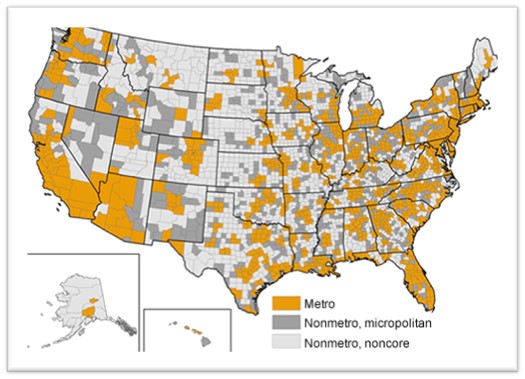
In 2013, OMB defined metropolitan (metro) areas as broad labor-market areas that include (Figure 2):
- Central counties with one or more urbanized areas; urbanized areas are densely settled urban entities with 50,000 or more people.
- Outlying counties that are economically tied to the core counties as measured by labor-force commuting. Outlying counties are included if 25% of workers living in the county commute to the central counties or if 25% of the employment in the county consists of workers coming out from the central counties – the so-called “reverse” commuting pattern.
Nonmetro counties are outside the boundaries of metro areas and are further subdivided into two types:
- Micropolitan (micro) areas are nonmetro labor-market areas centered on urban clusters of 10,000 – 49,999 persons and are defined with the same criteria used to determine metro areas.
- All remaining counties are often labeled “noncore” counties because they are not part of “core-based” metro or micro areas.[6]
Metro and micro areas accounted for about 94% of the population, while the remaining 6% were nonmetro areas in 2016. The land area in metro and micro areas was about 47%, and the remaining 53% was noncore.[7]
Figure 2. Metro, nonmetro micropolitan, and nonmetro noncore counties based on Office of Management and Budget’s delineation of urban areas and urban clusters, 2013

Source: Economic Research Service, U.S. Department of Agriculture
References
[1] U.S. Census Bureau: Understanding and Using American Community Survey Data – What Users of Data for Rural Areas Need to Know
[2] U.S. Census Bureau: Defining Rural at the U.S. Census Bureau. 2016. https://www.census.gov/content/dam/Census/library/publications/2016/acs/acsgeo-1.pdf
[3] Economic Research Service, U.S. Department of Agriculture: https://www.ers.usda.gov/topics/rural-economy-population/rural-classifications/#map
[4] U.S. Census Bureau: Defining Rural at the U.S. Census Bureau. 2016. https://www.census.gov/content/dam/Census/library/publications/2016/acs/acsgeo-1.pdf
[5] U.S. Census Bureau: Defining Rural at the U.S. Census Bureau. 2016. https://www.census.gov/content/dam/Census/library/publications/2016/acs/acsgeo-1.pdf
[6] Economic Research Service, U.S. Department of Agriculture. https://www.ers.usda.gov/topics/rural-economy-population/rural-classifications/what-is-rural/
[7] U.S. Census Bureau: Understanding and Using American Community Survey Data – What Users of Data for Rural Areas Need to Know
Author
Zuzana Bednarik, Ph.D., Research and Extension Specialist, North Central Regional Center for Rural Development
